Sponsored WEFTEC Product Launch presentations and Q&A sessions bring a new level of detail and technical specifications to exhibition programming.
Join us at the Product Launch Theater (Booth #5738 – Hall G)
Monday, Oct. 7 | 2:30 p.m. – 3:15 p.m.
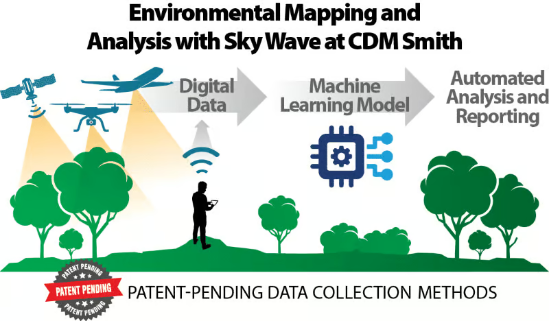
CDM Smith is once again sponsoring the WEFTEC Drone Pavilion which will feature Sky Wave™ at CDM Smith, its comprehensive solution for addressing environmental challenges that leverages drones, remote sensing, and machine learning to track and analyze surface changes.
Sky Wave: Transforming Data to Decisions Through Remote Sensing and Machine Learning
By capturing digital data through drones and sensors and applying machine learning for rapid processing, Sky Wave provides site analysis that’s faster, safer, more robust and more accurate.
Are you working on a project that is running into the following challenges?
- Incomplete site knowledge
- Time-consuming and expensive data collection
- Overwhelming data volume
- Concerns over field worker safety
- A need for data that traditional methods cannot address
Sky Wave will forever change the way environmental sites are assessed and analyzed. By leveraging drones, machine learning and decades of environmental science, CDM Smith has built a better solution to the age-old challenges and costs of site monitoring. With Sky Wave, you’ll gather vast quantities of data through patent-pending methods that enhance efficiency and accuracy. Rapid, accurate, AI-driven analysis will track environmental and surface changes. In other words, your site knowledge will go from analog to digital.
From coastal resilience and biodiversity monitoring to carbon capture and infrastructure development—there isn’t an environmental site that Sky Wave can’t handle. Through a seamless digital data pipeline, you’ll be able to avoid safety hazards and reduce boots-on-the-ground work hours. Sky Wave slashes your costs and boosts your resources. With robust and defensible data, you’ll gain satisfied regulators, delighted stakeholders and awed grant funders. By spending less on field data collection teams, you’ll have more money to put into the project itself. And with better and stronger analysis, you’ll be enroute to meeting and beating your environmental and compliance targets.
The Sky Wave team is using remote sensing and machine learning to help solve a wide array of environmental and infrastructure challenges.
- Wetland mapping and monitoring
- River and watershed morphology
- Green infrastructure
- Wind & solar facility siting
- Water quality monitoring
- TMDL discharge studies
- Ecological studies
- Construction progress
- Disaster and flooding response
- Impervious area assessment
- Dam, levee and pipeline condition assessment
- Climate resilience
At the federal, state and county level, our team is helping organizations to understand and track your project’s progress in granular detail. That means more certainty, less risk, and less cost over time. More so than the technology we use in the field or the software we use in the cloud, what makes Sky Wave unique is the way it helps you transform data into decisions.
Sponsored Content